Eagle Butte
| Site Name: | Eagle Butte | 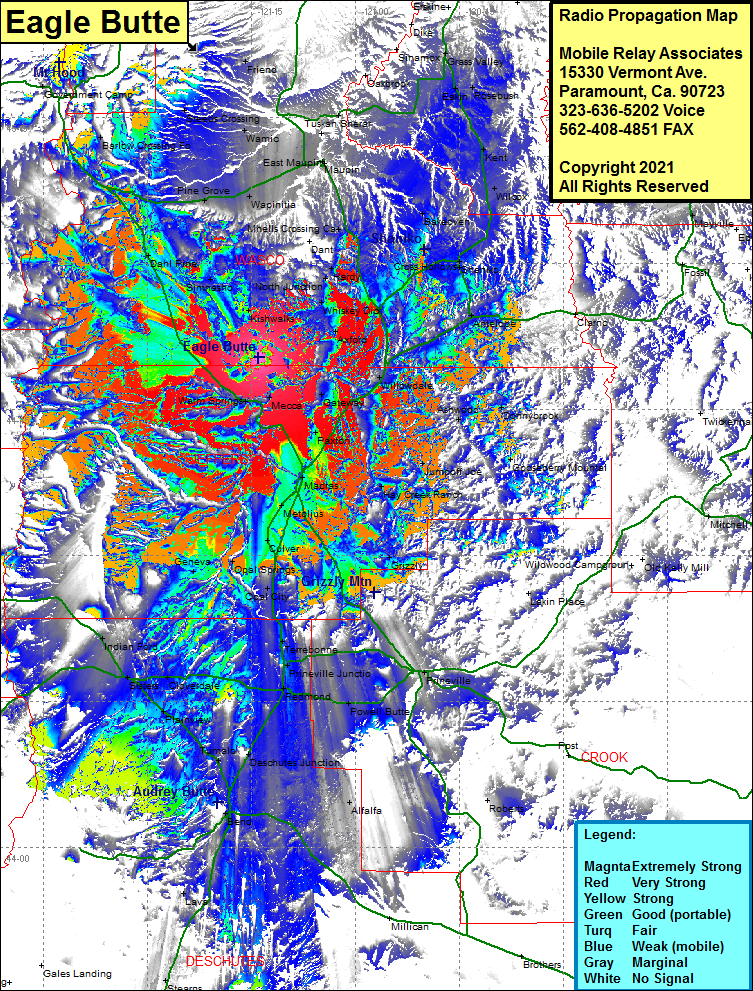 Eagle Butte Coverage |
| Latitude: | 044 50 23.9N | 44.8399722 |
| Longitude: | 121 13 59.1W | -121.2330833 |
| Feet | Meters | |
| Ground Elevation: | 3149.0 | 959.8 |
| HAAT: | 1064.1 | 324.3 |
| City: | Dahl Pine | |
| County: | Wasco | |
| State: | Oregon |
This is not an MRA Owned Site. For space rental contact the site owner.
Do you own or manage this site? Click Here
Would you like to add a site to the Google Earth Map?? Click Here
Site Coverage: Coverage of Mecca, Warm Springs, Dahl Pine, Simnasho, Kishwalks, Kahneeta Hot Springs, Gateway, Paxton, Madras Station, Masras, Willowdale, South Junction, Axford, Kaskela, Whiskey Dick, North Junction Hardy, Dixon, Dant, Shaniko Junction, Cross Hollows, Shaniko, Antelope, Cross Hollows, Ashwood, Jumpoff Joe, Black Place, Hay Creek Ranch, Grizzly, Opal City, Opal Springs, Geneva, Culver, Metolius, Lakin Place, Terrebonne, Forest Crossing, O’neil, Prineville Jct, Redmond, Cloverdale, Sisers, Indian Ford, Bakeoven, Wilcox, Wapinitia, Pine Grove, Roberts, Alfalfa, Bend, Turmalo, Plainview, Jack Shelter, Wamic, Oak Springs, Sherar, Tygh Valley, Kingsley, Oakbrook, Grass Valley, Kent, Bourbon, Rosebush, Rutledge, Steeds Crossing, Barlow Crossing, High Rock, Government Camp