One of the great benefits of current technology is the ability to obtain accurate location information for vehicles and personnel utilizing Global Positioning System (GPS) technology. When used in conjunction with a radio system or other reporting mechanism, you can accurately determine their location to about 100 feet or less using old GPS technology and about 10 feet or less using newer GPS technology.
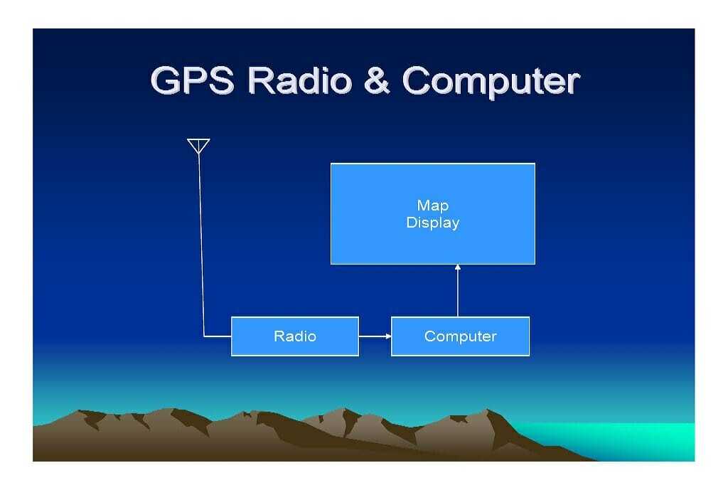
The GPS receiver that is located within your vehicle determines the vehicle location. However, the information about the location is located within the vehicle and not at any other location. Therefore, it is easy for one to know their own location with a GPS receiver, but that does not tell anyone else where they are located. In order for others to know the vehicle location, the data must be transmitted from the location of the GPS receiver to the place where the information is needed.
GPS DATA TRANSPORT
This need for GPS data requires some method of data transport. There are a few methods of transporting the data, each with their own advantages and disadvantages. The first method is for the vehicle operator to tell someone verbally which is an unreliable, cumbersome and slow method. The second method is to take the data and send it over a cellular system to a central location which is displayed on a website on the internet. Another method is to use a conventional radio system to transmit the data. A fourth method is to send the data over an analog trunked radio system. The last method is to send the data over a digital trunked radio network with multiple sites, similar to using a cellular radio system. Each method of sending the data has its advantages and disadvantages which will be discussed in another document on the website.
MRA operates a NEXEDGE network of trunked repeaters which is one of the better solutions to reporting GPS locations. There are two basic technologies for collecting the data and making it available for customer use:
.
- The first method is for each customer to have their own software GPS collecting and mapping program along with a GPS data base station attached to a computer to receive the GPS data sent from the vehicles to the office. The data base station in the office is connected to a dedicated computer with the GPS mapping program which will display the vehicle location on a map. The advantage of this technology is that the monthly costs are strictly for the airtime for the GPS data. However, the subscriber must purchase the hardware and software to set up the data transport, collection and mapping and continue to maintain the system.
- The second method is for the NEXEDGE network to collect the data through the IP network that connects all the sites together. The network sends this data to an IP data gate computer which is owned and maintained by MRA. The data gate creates a website which the subscriber can utilize to view their vehicles.
 We have a second map that has zoomed into the mid cities area. With this map, one can more clearly see the locations if different vehicles in the mid cities area and how they are spread out around that area.
  DATA COLLECTION TECHNIQUES There are three basic techniques for collecting the GPS data. The first method is to wait for the vehicle to talk on the radio. When the driver depresses the PTT button to speak to dispatch, a GPS location is sent with the voice transmission, letting the office know the location of the vehicle, but this technique requires the driver to initiate a call to know the vehicle location. The next technique is to be able to “poll” the vehicle to determine its location by sending a request to the radio to report its position. This can be done at any time that knowing the exact location is required. The third technique is to have the vehicle automatically report its position every so often so that you get to see the path driven by the vehicle which are known as history or otherwise known as “Bread crumbs” displaying on the map to show the vehicle path. When operating a large fleet of vehicles, having a history of the vehicle locations keeps you up to date on the routes taken by constantly moving vehicles. However, when considering the amount of data required to report all this information, it takes a considerable amount of airtime and one must evaluate how much one is willing to pay for up to the minute information. Some companies do not need to know so precisely the vehicle location every minute and are content to know that route the vehicle traveled at the end of the day. This requires the GPS to store information which can be downloaded at the end of the day instead of transmitting the position over the air in real time. Other companies want to be able to poll the vehicles any time they need to know the location while others want the information in real time with each vehicle updating its location every 10 minutes, 5 minutes, 2 minutes or 1 minute. MRA offers GPS reporting options and can tailor the system to the specific requirements that you need to manage your fleet. THE NEED FOR HISTORY Most subscribers need to know their vehicle locations, but do not need the history displayed on the map. The history will clutter the map and make it more difficult to read, especially if there is a large fleet of vehicles being tracked by GPS. However, some fleets desire to have their GPS position automatically reported in periodic updates so that the dispatcher always knows the location of the vehicle within a small margin of error. METHOD OF DATA COLLECTION There are 5 basic methods of collecting the GPS data over the NEXEDGE network. The methods are as follows:
- Randomly report the vehicle position
- Report the vehicle position when some event happens
- Report the vehicle position every X number of minutes
- Push-To-Talk (PTT)
- Poll
- The first method is for each customer to have their own software GPS collecting and mapping program along with a GPS data base station attached to a computer to receive the GPS data sent from the vehicles to the office. The data base station in the office is connected to a dedicated computer with the GPS mapping program which will display the vehicle location on a map. The advantage of this technology is that the monthly costs are strictly for the airtime for the GPS data. However, the subscriber must purchase the hardware and software to set up the data transport, collection and mapping and continue to maintain the system.
One of the great benefits of current technology is the ability to obtain accurate location information for vehicles and personnel utilizing Global Positioning System (GPS) technology. When used in conjunction with a radio system or other reporting mechanism, you can accurately determine their location to about 100 feet or less using old GPS technology and about 10 feet or less using newer GPS technology.
The GPS receiver that is located within your vehicle determines the vehicle location. However, the information about the location is located within the vehicle and not at any other location. Therefore, it is easy for one to know their own location with a GPS receiver, but that does not tell anyone else where they are located. In order for others to know the vehicle location, the data must be transmitted from the location of the GPS receiver to the place where the information is needed.
GPS DATA TRANSPORT
This need for GPS data requires some method of data transport. There are a few methods of transporting the data, each with their own advantages and disadvantages. The first method is for the vehicle operator to tell someone verbally which is an unreliable, cumbersome and slow method. The second method is to take the data and send it over a cellular system to a central location which is displayed on a website on the internet. Another method is to use a conventional radio system to transmit the data. A fourth method is to send the data over an analog trunked radio system. The last method is to send the data over a digital trunked radio network with multiple sites, similar to using a cellular radio system. Each method of sending the data has its advantages and disadvantages which will be discussed in another document on the website.
MRA operates a NEXEDGE network of trunked repeaters which is one of the better solutions to reporting GPS locations. There are two basic technologies for collecting the data and making it available for customer use:
.
-
- The first method is for each customer to have their own software GPS collecting and mapping program along with a GPS data base station attached to a computer to receive the GPS data sent from the vehicles to the office. The data base station in the office is connected to a dedicated computer with the GPS mapping program which will display the vehicle location on a map. The advantage of this technology is that the monthly costs are strictly for the airtime for the GPS data. However, the subscriber must purchase the hardware and software to set up the data transport, collection and mapping and continue to maintain the system.
- The second method is for the NEXEDGE network to collect the data through the IP network that connects all the sites together. The network sends this data to an IP data gate computer which is owned and maintained by MRA. The data gate creates a website which the subscriber can utilize to view their vehicles.
The most popular solution is the second method of viewing the vehicles on a website. User setup and complexity is minimized and the reliability and efficiency is increased using this technology. Generation 1 (Gen 1) of the NEXEDGE system handles the GPS with reasonable efficiency, especially when using radio firmware that is newer than Version 2.85 which added significant GPS features to the system. However, Generation 2 (Gen 2) NEXEDGE has even better GPS data collection techniques which resolve some of the intricate and lingering issues that were never resolved in Gen 1 systems. Currently, MRA is offering GPS on both Gen 1 and Gen 2, however, our network operation is slowly being converted to Gen 2 due to the GPS and many other improvements of the Gen 2 system.
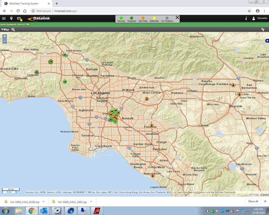
Below is a screen print of the GPS map from the website which displays the vehicle locations. In the print below, you can see many vehicles clustered within a small area around the mid cities area and some other vehicles spread out around the City of Los Angeles.
We have a second map that has zoomed into the mid cities area. With this map, one can more clearly see the locations if different vehicles in the mid cities area and how they are spread out around that area.
DATA COLLECTION TECHNIQUES
There are three basic techniques for collecting the GPS data. The first method is to wait for the vehicle to talk on the radio. When the driver depresses the PTT button to speak to dispatch, a GPS location is sent with the voice transmission, letting the office know the location of the vehicle, but this technique requires the driver to initiate a call to know the vehicle location. The next technique is to be able to “poll” the vehicle to determine its location by sending a request to the radio to report its position. This can be done at any time that knowing the exact location is required. The third technique is to have the vehicle automatically report its position every so often so that you get to see the path driven by the vehicle which are known as history or otherwise known as “Bread crumbs” displaying on the map to show the vehicle path.
When operating a large fleet of vehicles, having a history of the vehicle locations keeps you up to date on the routes taken by constantly moving vehicles. However, when considering the amount of data required to report all this information, it takes a considerable amount of airtime and one must evaluate how much one is willing to pay for up to the minute information. Some companies do not need to know so precisely the vehicle location every minute and are content to know that route the vehicle traveled at the end of the day. This requires the GPS to store information which can be downloaded at the end of the day instead of transmitting the position over the air in real time. Other companies want to be able to poll the vehicles any time they need to know the location while others want the information in real time with each vehicle updating its location every 10 minutes, 5 minutes, 2 minutes or 1 minute. MRA offers GPS reporting options and can tailor the system to the specific requirements that you need to manage your fleet.
THE NEED FOR HISTORY
Most subscribers need to know their vehicle locations, but do not need the history displayed on the map. The history will clutter the map and make it more difficult to read, especially if there is a large fleet of vehicles being tracked by GPS. However, some fleets desire to have their GPS position automatically reported in periodic updates so that the dispatcher always knows the location of the vehicle within a small margin of error.
METHOD OF DATA COLLECTION
There are 5 basic methods of collecting the GPS data over the NEXEDGE network. The methods are as follows:
- Randomly report the vehicle position
- Report the vehicle position when some event happens
- Report the vehicle position every X number of minutes
- Push-To-Talk (PTT)
- Poll
Method 1 and method 2 both have certain difficulty because the data is sent at random times. When hundreds of GPS equipped vehicles report at random times, there tends to be a lot of data collisions, thus causing the data to be resent. This increases the traffic on the network and the airtime consumed by the GPS system. The more traffic, the greater the number of data collisions. If enough data collisions occur, then the system goes into “runaway” data collisions where there are so many data collisions which cause the data to be resent causing more data collisions and eventually there is nothing but data collisions.
The only automatic method that maintains order in the system is to use method 3 to report GPS data locations. This method schedules the radio to report its GPS location in a specific time slot. Since there are only so many time slots on the network, there is a limit on the number of radios that can automatically report its GPS location before all the time slots are used.
The PTT method sends a GPS data location every time the driver picks up the microphone and talks on the radio. Therefore, you immediately know their location when speaking to them. It is updated any time they talk on the radio.
Poll is the ability for the office to send a request to the vehicle for a GPS location. This can be done at any time by the dispatcher at any time they desire to know the updated location of the vehicle if they have not talked on the radio.
We offer a very economical package of PTT and Poll GPS reporting that allows you to be able to see your vehicles on a map. When combined with our voice offering, no one can provide you with GPS vehicle location at a price that approaches our offering. If you need to have automatic reporting, you need to speak with one of our communication specialists to devise a program that will fit your needs at a price the makes sense to you.
- The first method is for each customer to have their own software GPS collecting and mapping program along with a GPS data base station attached to a computer to receive the GPS data sent from the vehicles to the office. The data base station in the office is connected to a dedicated computer with the GPS mapping program which will display the vehicle location on a map. The advantage of this technology is that the monthly costs are strictly for the airtime for the GPS data. However, the subscriber must purchase the hardware and software to set up the data transport, collection and mapping and continue to maintain the system.