Google Earth Map
Last modified: March 13 2026
Previous Version: February 13 2026
View Radio Tower Sites in Google Earth
Our Google Earth map is unique, a one of a kind that you will not find anywhere else on the internet. The map has stick pins that locate over 1300 radio sites in the western United States and continues to grow as we find more tower sites. We have gone to great lengths to locate common tower sites that can be used for two-way radio systems. The majority of the sites are on top of hills, mountains or other high locations. We did not include “public safety only” low level sites, nor did we attempt to include cellular sites except in rare instances.
The map also contains many “Easter Eggs” that are hidden throughout the map. You will know when you find one of the eggs because you will read about some character from history, TV or movies and something about their adventures.
When you download the map, you can right click the map and save it to “My Places” in your Google Earth map so that our map is always available to you. Alternatively, you can save it to your “temporary locations” if you tell Google Earth to save it upon exiting the program. Aside from being able to locate the tower sites, you can click the “Details” link for the site in which the map will take you to a page on our website giving you the important technical information about the site and radio coverage from the site. If you scroll to the bottom of the page, you will see the link to display the radio coverage for the site on Google Earth. Click the button and you will return to Google Earth with the coverage displayed over Google Earth.
There are several different color pins on the map. The purple pins (which we call “Barneys” after the cartoon purple dinosaur) represent sites that do not have any information about the site beyond what you can determine from the stick pin. All other colors have pages on our website to inform you about the site. The legend on the map indicates the meaning of the different colors.
We are actively engaged in “Barney” killing which means that we are trying to eliminate the purple stick pins by creating pages on our website to provide you with the information about the site. Periodically, we update the map after we have killed off a significant number of Barneys. Our goal can be extracted from the poem below that can be sung to the melody of the famous Barney theme song:
I hate you, you hate me,
We’re a miserable family,
I’ll go and buy a gun from the store,
Then no more PURPLE dinosaur!
Enjoy the map and make good use of it. It will make so much of your coverage prediction work easy and fun. Good Luck!!!
GOOGLE EARTH MAP
View Radio Tower Sites in Google Earth
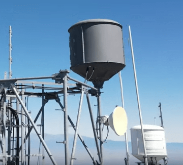
We have been asked many times what is in the buildings at the top of the mountain by hikers who are not familiar with the radio business. That varies a lot by tower site because each site presents unique radio propagation characteristics that favor different industries. In general, you will find TV stations, FM radio stations, on rare occasions there will be an AM radio station on top of a mountain, police radio, fire departments, public works, bus transportation, ambulance dispatch, tow trucks, paging (yes there still are pagers in existence, but it is a dwindling industry), cellular phone companies use the high tower sites to link their cell sites together with microwave (point to point links) and in the rural areas, they use the high tower sites for the cellular coverage. You may notice structures that look like a water tank. Those antennas are remotely steerable microwave dishes that are used by the TV station for remote pickup. They point the antenna at the news van and the news van points their telescoping antenna at the mountain. The signal is sent by the van to the mountain which relays the signal to the station directly or through another intermediate location to get the signal back to the studios so that it can be inserted into the program.
One site that generates the greatest number of inquiries is Santiago Peak in SE Orange County. There are approximately 20 different facilities on top of the peak which are owned by a variety of companies. One of the buildings is owned by us (MRA) which we use for our wide area digital network that allows anyone who subscribes to our service to talk from Santa Maria to the Mexican boarder and from the Pacific Ocean to Saint George, Utah, into the Coachella Valley, Imperial Valley, Yuma, Arizona and the eastern Sierra heading up to Reno. Our analog radio systems are used by various industries to talk over the LA area plus we rent space on our radio tower to others who have uses for the site for their own purposes. Other buildings at the peak are owned by American Tower and Crown Castle, two large companies on the stock exchange that own towers across the country and rent space on the towers. Other buildings are owned by the FBI, Orange County, Riverside County, US Air Force, other two way radio companies, such as Touch Tel Corp and Day Wireless, Southern California Edison and others for their own internal communications.
Instructional video for the map above
Below is an instructional video on the use of our Google Earth map. It shows you step by step the different things you can do with the map. If you have the time, it will probably show you things that you did not know about the map.