Crystal Lake
| Site Name: | Crystal Lake | 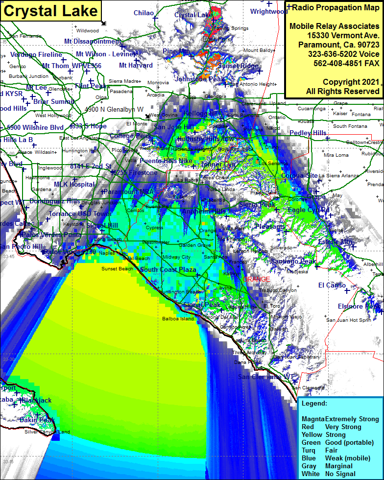 Crystal Lake Coverage |
| Latitude: | 034 18 40.6N | 34.3112778 |
| Longitude: | 117 50 10.4W | -117.8362222 |
| Feet | Meters | |
| Ground Elevation: | 5021.0 | 1530.4 |
| HAAT: | 338.5 | 103.2 |
| City: | Azusa | |
| County: | Los Angeles | |
| State: | California |
This is not an MRA Owned Site. For space rental contact the site owner.
Do you own or manage this site? Click Here
Would you like to add a site to the Google Earth Map?? Click Here
Site Coverage: Coverage of Highway 39 from Azusa to Angeles Crest Highway, Bassett, South El Monte, West Covina, Covina, Charter Oak, San Dimas, La Verne, North Pomona, Pomona, Diamond Bar, Rowland Heights, Hacienda Heights, La Puente, Bassett, Baldwin Park, Narod, Claremont, Chino, Los Serranos, Prado Dam, Corona, Weisel, Sleepy Hollow, Artesia, Cerritos, Bellflower, Lakewood, Hawaiian Gardens, Cypress, Hansen, Los Alamitos, Stanton, Garden Grove, Orange, Anaheim, Santa Ana, Tustin, Founain Valley, Midway City, Sunset Beach, Seal Beach, Los Altos, Bellmont Shore, Long Beach, Irvine, Costa Mesa, El Toro, Frances, Newport Beach
Amateur (ham) frequencies: