Hilltop II
| Site Name: | Hilltop II | 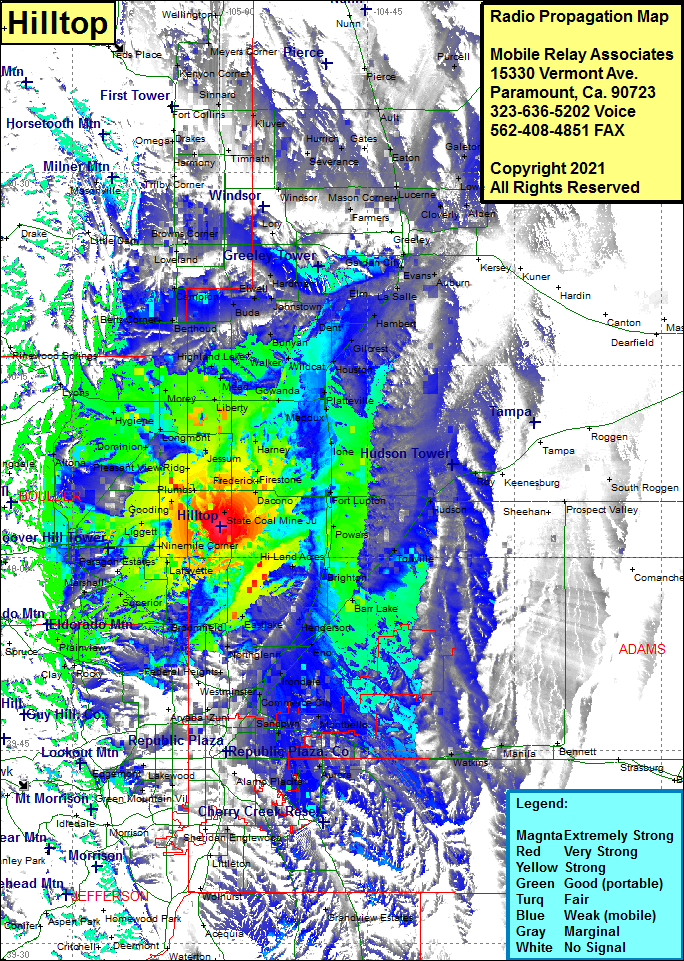 Hilltop II Coverage |
| Latitude: | 040 02 26.2N | 40.0406111 |
| Longitude: | 104 59 53.8W | -104.9982778 |
| Feet | Meters | |
| Ground Elevation: | 5265.0 | 1604.8 |
| HAAT: | 326.5 | 99.5 |
| City: | Erie | |
| County: | Weld | |
| State: | Colorado |
This is not an MRA Owned Site. For space rental contact the site owner.
Do you own or manage this site? Click Here
Would you like to add a site to the Google Earth Map?? Click Here
Site Coverage: Coverage of Lyons, Altona, Hygiene, Morey, Liberty, Mead, Highland Lake, Berthud, Berts Corner, Campion, Welty, Buda, Elwell, Loveland, Kings Corner, Browns Corner, Redmond, Windsor, Gove, Lory, Hardman, Johnstown, Adna, Elm, Dent, Garden City, Greeley Junction, Mason Corner, Lucerne, Lowe, Cloverly, Alden, Auburn, Evans, LaSalle, Hambert, Gilcrest, Houston, Wildcat, Bunyan, Walker, Gowanda, Platteville, Maddux, Ione, Vollmar, Harney, Jessum, Frederick, Firestone, Dacono, Puritan, Plumbs, Gooding, Liggett, Leyner, State Coal Mine Junction, Saint Vrains. Fort Lupton, Powars, Hudson, Roy, Tonville, Brighton, Barr Lake, Henderson, Hazeltine, Rolla, Federal Heights, Northglenn, Eastlake, Broomfield, Semper, Commerce City, Montbello, Sable, Magee, Sandown, Watkins, Manila, Aurora, Wallace Village, Broomfield, Superior, Marshall, Louisville, Lafayette, Ninemile Corner, Paragon Estates, Plainview, Clay, Rocky, Mount Olivett, Paragon Estates, Valmont, Liggett, Leyner, Tabor, Ara, Boulder, Altona, Hygiene