Hoover Hill Tower
| Site Name: | Hoover Hill Tower | 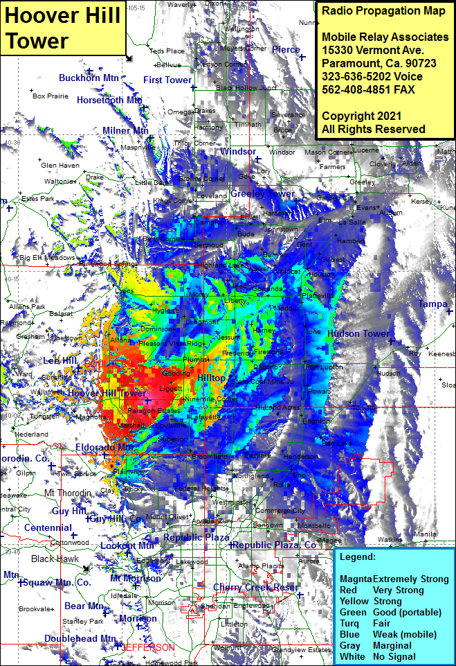 Hoover Hill Tower Coverage |
| Latitude: | 040 00 43.0N | 40.0119444 |
| Longitude: | 105 11 18.0W | -105.1883333 |
| Feet | Meters | |
| Ground Elevation: | 5341.0 | 1627.9 |
| HAAT: | -2.6 | -0.8 |
| City: | Boulder | |
| County: | Boulder | |
| State: | Colorado |
This is not an MRA Owned Site. For space rental contact the site owner.
Do you own or manage this site? Click Here
Would you like to add a site to the Google Earth Map?? Click Here
Site Coverage: Coverage of Boulder, Altona, Lyons. Noland, Pinewood Springs, Berts Corner, Berthoud, Campion, Kings Corner, Loveland, Browns, Corner, Redmond, Timnath, Kerns, Windsor, Greeley Jct, Masorn Corner, Lucerne, Eator, Gates, Severance, Hurrich, Ault, Stage, Pierce, Purcell, Galeton, Lowe, Alden, Alburn, East LaSalle, Hambert, Elm, Adna, Dent, Johnstown, Hardman, Elwell, Welty, Buda, Bunyan, Wildcat, Walker, Houston, Gilcrest, Platteville, Gowanda, Liberty, Kirkland, Longmont, Marnett, Hygiene, Dominion, Pleasant View Ridge, Jessum, Frederick, Firestone, Harney, Vollmar, Old Fort Vasquez, Ione, Fort Lupton, Hudson, Tonville, Barr Lake, Brighton, Powars, Hi-Land Acres, Saint Vrains, State Coal Mine Jct, Plumbs, Gooding, Leyner, Ninemile Corner, Lafayette, Louisville, Paragon Estates, Superior, Marshall, Broomfield, Eastlake, Henderson, Hazeltine, Rolla, Northglenn, Federal Heights, Semper, Wallace Village, Plainview, Rocky, Clay, Leyden Junction, Mount Olivet, Commerce City, Montbello, Sable, Sandown, Zuni, Wheat Ridge, Magee