Milner Mountain
| Site Name: | Milner Mountain | 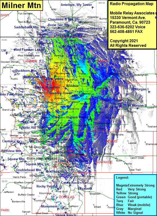 Milner Mountain Coverage |
| Latitude: | 040 29 36.1N | 40.4933611 |
| Longitude: | 105 10 54.1W | -105.1816944 |
| Feet | Meters | |
| Ground Elevation: | 6785.0 | 2068.1 |
| HAAT: | 1009.8 | 307.8 |
| City: | Masonville | |
| County: | Larimer | |
| State: | Colorado |
This is not an MRA Owned Site. For space rental contact the site owner.
Do you own or manage this site? Click Here
Would you like to add a site to the Google Earth Map?? Click Here
Site Coverage: Coverage of Masonville, Trilby Corner, Omega, Drakes, Fort Collins, Kluver, Timnath, Severance, Gates, Easton, Lucene, Lowe, Galeton, Matthews, Alden, Cornish, Fosston, Briggsdale, Purcel, Pierce, Ault, Kenyon Corner, Wellington, Dixon, Waverly, Bulger, Buckeye, Norfolk, Warren, Gleason, Atol, Harriman, Virginia Dale, Arcola, Carpenter, Hereford, Grover, Keota, Buckingham, Kersey, Kuner, Hardin, Canton, Masters, Orchard, Goodrich, Weldone, Greeley, Garden City, Evans, Elm, Hambert, Gilcrest, Wildcat, Bunyan, Johnstown, Elwell, Buda, Campion, Lory, Litle Dam, Kings Corner, Berts Corner, Berthoud, Highland Lake, Mead, Morey, Kirkland, Longmont, Hygiene, Dominion, Idaho Creek, Niwot, Firestone, Dacono, Ione, Maddux, Platteville, Idaho Creek, Fort Lupton, Hudson, Roy, Keenesburg, Prospect Valley, Sloan, Tampa, Roggen, Tonville, Powars, Brighton, Barr Lake, Comanche, Eno, Irondale, Northglenn, Eastlake, Broomfield, Montbello, Westminster, Arvada, Wheat Ridge, Denver, Watkins, Manila, Bennett, Aurora, Elglewood, Littleton, Sheridan, Lakewood