Harrison Mtn
| Site Name: | Harrison Mtn | 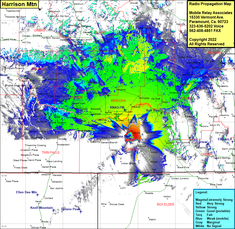 Harrison Mtn Coverage |
| Latitude: | 042 20 05.7N | 42.3349167 |
| Longitude: | 113 36 18.0W | -113.6050000 |
| Feet | Meters | |
| Ground Elevation: | 8190.0 | 2,496.3 |
| HAAT: | 2,389.7 | 728.4 |
| City: | Connor | |
| County: | Cassia | |
| State: | Idaho |
This is not an MRA Owned Site. For space rental contact the site owner.
Do you own or manage this site? Click Here
Would you like to add a site to the Google Earth Map?? Click Here
Site Coverage: Coverage of Albion, Declo, Rupert, Acequia, Minidoka, Norland, Cream Can Junction, Tepee Circles, Smith Corrals, Scoville, Taber, Havens, Rockford, Liberty, Pingree, Springfiels, Coffee Point, Grandview, Fingal, Aberdeen, Tyhee, Bannock, Fairview, American Falls, Rockland, Heglar, Sublett, Juniper, Bridge, Keogh, Elba, Malta, Idahome, Cotteral, Declo, Albion, Connor, Elba, View, Heyburn, Rupert, Acequia, Smith Springs, Wapi, DeWolf, Quigley, Minidoka, Heyburn, Burley, Hobson, Pella, Beetville, North Kenyon, Trout, Iversons, Garrard Branch, Artesian City, Rock Creek, Murlaugh, Minler, Hynes, Schodde, Hazelton, Bickel, Hansen, Bills, Clay Caves, Twin Falls, Sugar Loaf, Barrymore, Hydra, Jerome, Peavey, Filer, Knull, Glover, Fairview, Buhl, Deep Creek, Wendell, Tuttle, Fuller, Gooding, Tunapa, Shoshone, Dietrich, Owinza, Kimama, Norland, Burmah, Pagan, Tikura, Carey, Pacabo, Gannett, Magic City, Magic Resort, Hot Springs Landing, Doniphan, Tepee Circles