Relay Ridge
| Site Name: | Relay Ridge | 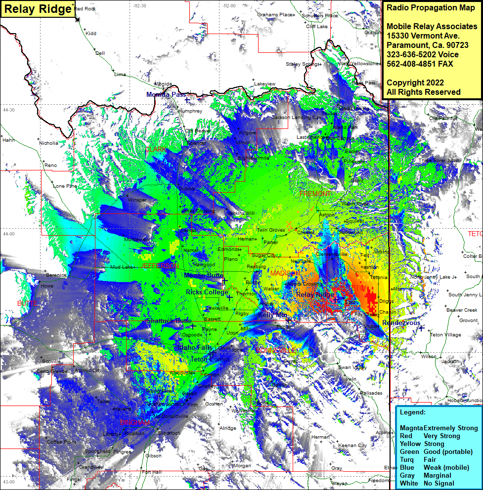 Relay Ridge Coverage |
| Latitude: | 043 42 41.9N | 43.7116389 |
| Longitude: | 111 20 59.3W | -111.3498056 |
| Feet | Meters | |
| Ground Elevation: | 8797.0 | 2,681.3 |
| HAAT: | 1,955.0 | 595.9 |
| City: | Sam | |
| County: | Teton | |
| State: | Idaho |
This is not an MRA Owned Site. For space rental contact the site owner.
Do you own or manage this site? Click Here
Would you like to add a site to the Google Earth Map?? Click Here
Site Coverage: Coverage of Sam, Cedron, Victor, Fox Creek, Driggs, Alta, Irwin, Palisades, Guyaz, Dehlin, Bone, Morgan, Goshan, Poplar, Milo, Ucon, Iona, Orvin, Osgood, Payne, Bassett, Rigby, Archer, Walker, Burton, Thornton, Lewisville, Idaho Falls, Cotton, Shelley, Basalt, Firth, Goshen Junction, Rising River, Woodville, McDonaldville, Blackfoot, Rockford, Liberty, Pingree, Springfield, Grandview, Fingal, Aberdeen, Havens, Taber, Atomic City, Cerro Grande, Scoville, Howe, Bernice, Mud Lake, Monteview, Winsper, Hawgood, Harmer, Camas, Jones Crossing, Dubois, Spencer, Humphrey, Kilgore, Idmon, Eighteenmile, Jenkins Will, Plano, Rexburg, Sugar City, Herman, Parker, Twin Groves, Chester, Teton, Newdale, Clementsville, Ashton, Squirrel, Warm River, Gerrit, Pineview, Eccles, Box Canyon, Last Chance, Macks Inn PO, Three River Junction, West Thumb, Judkins, Felt, Ashton, Tetonia