Squaw Butte
| Site Name: | Squaw Butte | 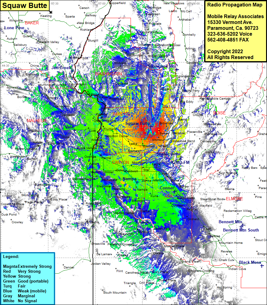 Squaw Butte Coverage |
| Latitude: | 044 00 14.3N | 44.0039722 |
| Longitude: | 116 24 42.3W | -116.4117500 |
| Feet | Meters | |
| Ground Elevation: | 5872.0 | 1,789.8 |
| HAAT: | 2,677.7 | 816.2 |
| City: | Black Canyon | |
| County: | Gem | |
| State: | Idaho |
This is not an MRA Owned Site. For space rental contact the site owner.
Do you own or manage this site? Click Here
Would you like to add a site to the Google Earth Map?? Click Here
Site Coverage: Coverage of Gross, Grangeville, Donnelly, Arling, Eagle Nest, Cascade, Smiths Ferry, Big Eddy, Crouch, Banks, Gardena, Grimes Pass, Washington Mill, Horshoe Bend, Montoru, Sweet, Brownlee, Pearl, Eagle, Ustick, Garden City, Boise, Barber, Blacks Creek, Regina, Mayfield, Orchard, Cleft, Sebree, Owyhee, Meridian, Kuna, Sonna, Nampa, Bowmont, Melba, Kpayette, Murphy, Swan Falls, Grand View, Walters Ferry, Reynolds, Petersons Crossing, Carothers Place, Spiry Place, Doyle Place, Swartz Corner, Riverside, Fischer, Nampa, Homedale, Claytonia, Owyhee Heights, Roswell, Owyhee, Apple Valley, Nyssa, Arcadia, Luse, Fruitland, Hamilton Corner, Lotha, Emmett, Bramwell, Josephon, Middleton, Eagle, Ustick, Doles, Wilder, Amsco, Parma, Ontario Heights, Vale, Lancaster, Jamieson, Brogan, Bonita, Payette, Wood, Crystal, Feltham, Rebecca, Weiser, Eaton, Crawford Place, Midvale, Little Rock, Palisades Corner, Buckingham, New Plymouth, Ingard, Ontario Heights, Washoe, French Corner, Sweet, Montour, Gardena, Beer Bottle Crossing, Indian Valley, Hoover, Fruitvale, Mesa, Goodrich, Cambridge, Grangeville, Black Canyon