Drake X
| Site Name: | Drake X | 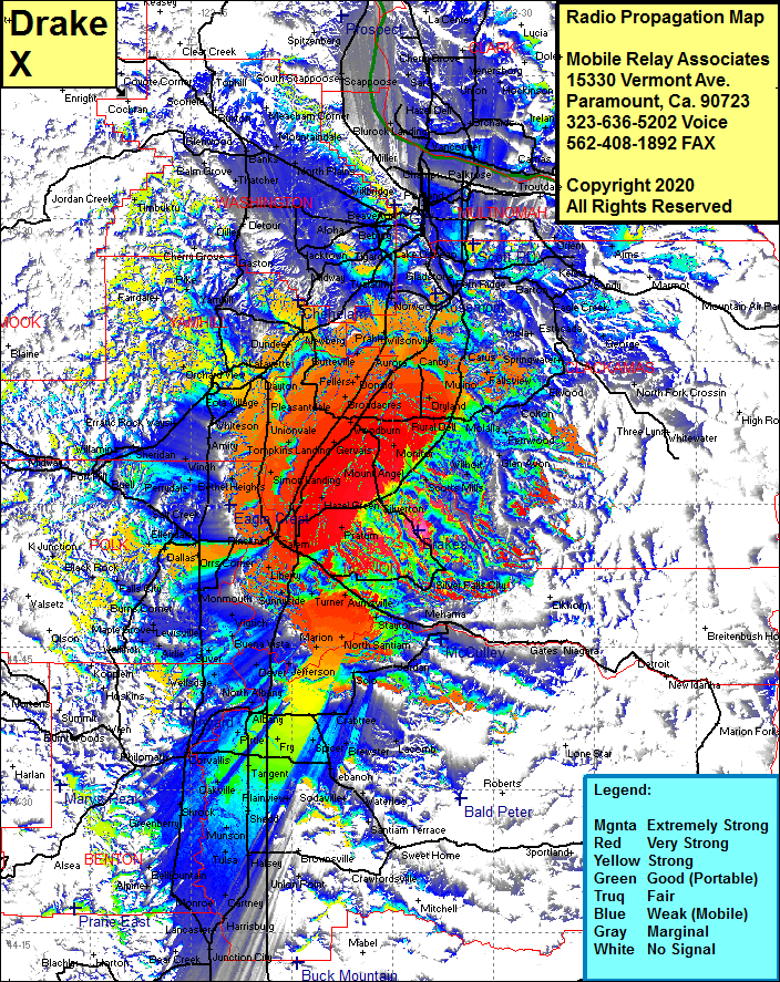 Drake X Coverage |
| Latitude: | 044 57 12.9N | 44.9535833 |
| Longitude: | 122 41 14.6W | -122.6873889 |
| Feet | Meters | |
| Ground Elevation: | 1479.0 | 450.8 |
| HAAT: | 559.9 | 170.7 |
| City: | Silverton | |
| County: | Marion | |
| State: | Oregon |
This is not an MRA Owned Site. For space rental contact the site owner.
Do you own or manage this site? Click Here
Would you like to add a site to the Google Earth Map?? Click Here
Site Coverage: Coverage of Fruitland, Middle Grove, Hazel Green, North Howell, Gervais, Monitor, Oaklawn, Rural Delli, Whiskey Hill, Dryland, Lone Elder, Canby, Barlow, Aurora, Wilsonville, Prahl, Ladd Hill, Champoeg, Fargo, Fellers, Donald, Broadacres, Saint Louis, Waconda, Hopmere, Quinaby, Clear Lake, Lakebrook, Simon Landing, Tompkins Landing, Whites Landing, Fairfield, Durettes Landing, Simon Landing, Unionvale, Pleasantdale, Lafayette, Saint Joseph, Erratic Rock, Bellevue, Sheridan, Shipley, Willamina, Midway, Modeville, Talbo, Devar, Wellsdale, Suver, Pedee. Dallas, Blackrock, Portland, Aloha, Hazeldale, Hillsboro, Blooming, North Plains, Mountaindale, Valle Vista