Eagle Crest
| Site Name: | Eagle Crest | 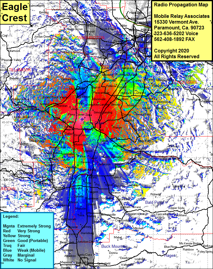 Eagle Crest Coverage |
| Latitude: | 044 59 49.6N | 44.9971111 |
| Longitude: | 123 09 14.7W | -123.1540833 |
| Feet | Meters | |
| Ground Elevation: | 988.0 | 301.1 |
| HAAT: | 776.2 | 236.6 |
| City: | Lincoln | |
| County: | Polk | |
| State: | Oregon |
This is not an MRA Owned Site. For space rental contact the site owner.
Do you own or manage this site? Click Here
Would you like to add a site to the Google Earth Map?? Click Here
Site Coverage: Coverage of Bethel, Lincoln, Lakebrook, Simon Landing, Waconda, Gervais, Woodburn, Monitor, Oaklawn, Mount Angel, Downs, Marquam, Scott Mills, Wilhoit, Glen Avon, Dickey Prarie, Frenwood, Motalla, Colton, Elwood, Dodge, Springwater, Estachada, Massinger Corner, Fishers Corner, Carus, Fallsview, Union Mills, Whisky Hill, Dryland, Lone Elder, Aurora, Canby, Barlow, Wilsonville, Pulp, Norwood, Mulby, Sherwood, Herrmah, Jean, Tigard, Metzger, Bradley Corner, Nesmith, Robinson, Bull Mountain, Middleton, Yotaw, Tigard, Kinton, Hazeldale, Laurel, Buckheaven, Sunnycrest, Yamhill, Carlton, Lafayette, Pleasantdale, Whiteson, Waysi, Amity, Bellevue, Sheridan, Shipley, Valley Jct, Midway, Buell, Salt Creek, Smithfield, Dolph Corner, Ellendale, Dallas, Fern Coner, Lewisville, Wallinch, Tarter, Kopplein, Ritner, Kings Valley, Hoskins, Nashville, Marval, Vurnt Woods, Chitwood, Nortons, Monmouth, Orville, Moderville, Talbo, Dever, Millerburg, Albany, Corvalis, Dry Creek, Shrock, Peoria, Potter, Tulsa, Miller, Alpine Jct, Tallman, Irvinvalle, Spicer, Bellfountain, Monroe, Lancaster, Bear Creek, Awbrey, Santa Clara and more