McCulley
| Site Name: | McCulley | 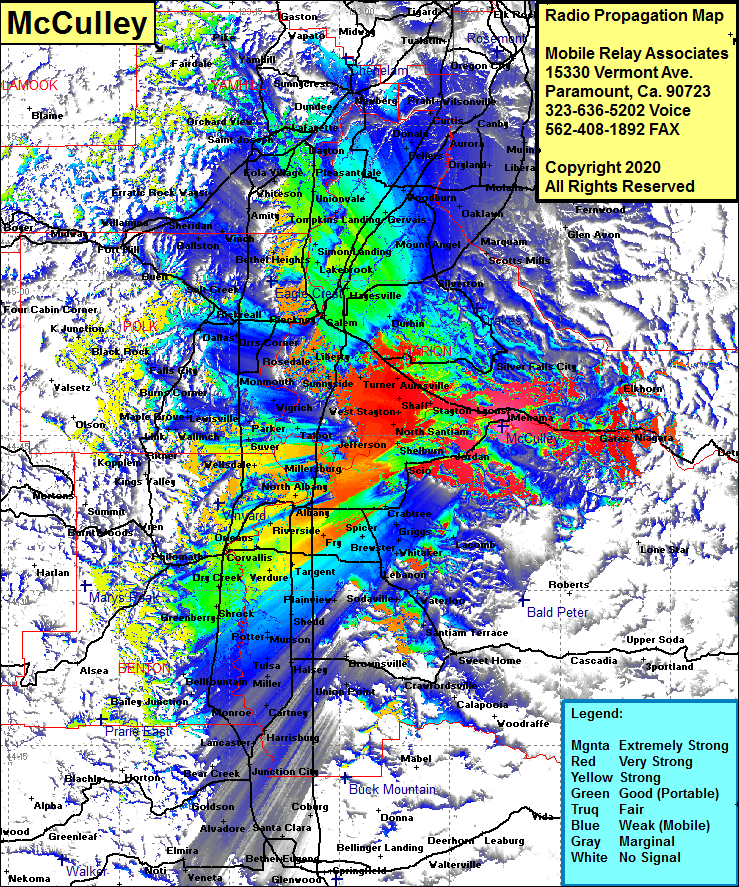 McCulley Coverage |
| Latitude: | 044 45 47.9N | 44.7633056 |
| Longitude: | 122 37 52.3W | -122.6311944 |
| Feet | Meters | |
| Ground Elevation: | 1619.0 | 493.5 |
| HAAT: | 418.1 | 127.4 |
| City: | Lyons | |
| County: | Linn | |
| State: | Oregon |
This is not an MRA Owned Site. For space rental contact the site owner.
Do you own or manage this site? Click Here
Would you like to add a site to the Google Earth Map?? Click Here
Site Coverage: Coverage of Lyons, Mehana, Gooch, Gates, Niagara, Stayton, North Santiam, Shelburn, Scio, Jordan, Crabtree, Griggs, Brewster, Lacomb, Lebanon, Sodaville, Waterloo, Santiam Terrace, Foster, Sweet Home, Greenville, Crawfordsville, Union Point, Rowland, Harrisburg, Cartney, Potter, Fayetteville, Sheda, Shrock, Philomath, Corvallis, Wren, Blodgett, Marval, Palestine, Suver, Wigrich, Monmouth, Brunks Corner, Deny, Salt Creek, Grand Ronde, Willamina, Shipley, Sheridan, Bellevue, Whiteson, Amity, Pleasantdale, Dayton, Lafayette, Carlton, Yamhill, Dundee, Newberg, Curtis Prahl, Wilsonville, Aurora, Unionvale, Lakebrook, Gervais, Monitor, Mount Angel, Broadacres, Oaklawn, Downs, Colton, Elwood, Glen Avon, Kokel Corner, Wilhoit, Scotts Mills, Elkhorn