Mt Scott
| Site Name: | Mt Scott | 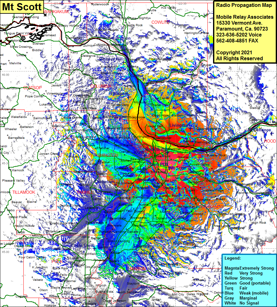 Mt Scott Coverage |
| Latitude: | 045 27 11.4N | 45.4531667 |
| Longitude: | 122 32 51.3W | -122.5475833 |
| Feet | Meters | |
| Ground Elevation: | 1049.0 | 319.7 |
| HAAT: | 789.7 | 240.7 |
| City: | Harmony | |
| County: | Clackamas | |
| State: | Oregon |
This is not an MRA Owned Site. For space rental contact the site owner.
Do you own or manage this site? Click Here
Would you like to add a site to the Google Earth Map?? Click Here
Site Coverage: Coverage of West Linn, Oregon City, Viola, Canby, Clarkes, Elwood, Three Lynx, Whitewater, Molalla, Woodburn, Scotts Mills, Drake Crossing, Silver Falls City, Turner, Modeville, Albany, Tulsa, Corvallis, Salem, Keizer, Smithfield, Minto, McMinnville, Dayton, Dundee, Newberg, Fargo, Chehalen, Sherwood, Oregon City, Viola, Clarkes, Molalla, Elwood, Estacada, Three Lynx, Whitewater, North Fork Crossing, Zigzag, Marmot, Gervais, Daytonville, Orchard View, Pike, Cherry Grove, Gaston, Beaverton, Banks, North Plains, Linnton, Haxel Deli, Meacham Corner, Scappoose, Spitzenberg, McNutty, Woodland, Etna, Ariel, Vernonia, Canaan, Woodland Park, Prescott, Longview, Mayger, Couger, Lucia, Yacolt, Dole, Crestwell Heights, Camas, Troutdale, Bridal Veil, Dodson, Skamania, Zigzag, Rhododendron, North Fork Crossing, Marmot, Sandy, Barton, West Linn