Prarie East
| Site Name: | Prarie East | 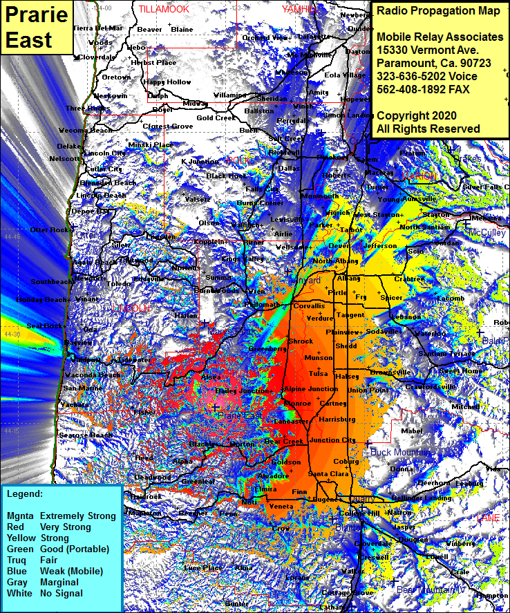 Prarie East Coverage |
| Latitude: | 044 17 28.5N | 44.2912500 |
| Longitude: | 123 32 21.9W | -123.5394167 |
| Feet | Meters | |
| Ground Elevation: | 3327.0 | 1014.1 |
| HAAT: | 2342.2 | 713.9 |
| City: | Alsea | |
| County: | Lincoln | |
| State: | Oregon |
This is not an MRA Owned Site. For space rental contact the site owner.
Do you own or manage this site? Click Here
Would you like to add a site to the Google Earth Map?? Click Here
Site Coverage: Coverage of Blachly, Harton, Goldson, Bear Creek, Junction City, Lancaster, Monroe, Alpine, Bellfountain, Greenberry Shrock, Dry Creek, Corvallis, Philomath, Conroy, Neon, Wren, Alder, Kings Valley, Wellsdale, Riverside, Page, Pirtle, Albany, Palestine, Millersburg, Draperville, Fry, Tangent, Verdure, Oakville, Wellsdale, Ritner, Kopplein, Hoskins, Monmouth, Wigrich, Judson Landing, Moderville, Talbet, Clow Corner, Dallas, Elendale, Brownsville, Crawfordsville, Sweet Home, Cascadia, Wendling, Deerhorn, Donna, Pleasantville, Jasper, Goshen, Lowell, Cloverdale, Walker, Cottage Grove, Lathan, Elmira, Veneta, Bethel, Eugene, Danebo, Noti, Walton, Deerhorn, Lowell, Hampton, Westfir and more….