Prospect
| Site Name: | Prospect | 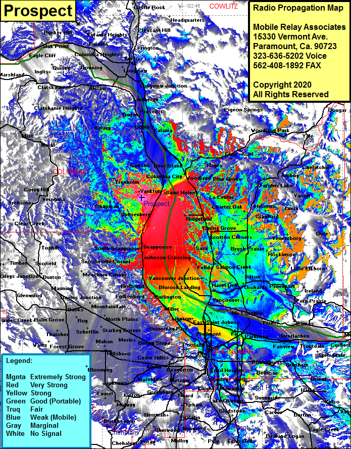 Prospect Coverage |
| Latitude: | 045 51 14.4N | 45.8540000 |
| Longitude: | 122 52 37.7W | -122.8771389 |
| Feet | Meters | |
| Ground Elevation: | 354.0 | 107.9 |
| HAAT: | -62.8 | -19.1 |
| City: | McNutty | |
| County: | Columbia | |
| State: | Oregon |
This is not an MRA Owned Site. For space rental contact the site owner.
Do you own or manage this site? Click Here
Would you like to add a site to the Google Earth Map?? Click Here
Site Coverage: Coverage of Portland, Parkrose, Kenton, United Jct, Vancouver, Salmon Creek, Sara, Rye, Dollar Corner, Ridgefield, La Center, Heisson, Lucia, Yacolt, Dole, Chelatchie, Amboy, Yale, Cougar, Woodland Park, Pigeon Springs, Hayes, Woodland, Deer Island, Canaan, Columbia City, Yankton, Spitzenberg, Warren, Folkenberg, North Plains, West Union, Merle, West Slope, Beaverton, Tobias, Hazeldale, Kinton, Sherwood, Laurel, Haley, Boring, Lekso, Sandy, Cherryville, Dilley, Banks, Detour, Apiary, Clatskanie Heights, Alston, Downing, Longview, Kelso, Lexington and more…