Raineer Hill
| Site Name: | Raineer Hill |  Raineer Hill Coverage |
| Latitude: | 046 02 58.4N | 46.0495556 |
| Longitude: | 122 55 13.7W | -122.9204722 |
| Feet | Meters | |
| Ground Elevation: | 1144.0 | 348.7 |
| HAAT: | 752.2 | 229.3 |
| City: | Prescott | |
| County: | Columbia | |
| State: | Oregon |
This is not an MRA Owned Site. For space rental contact the site owner.
Do you own or manage this site? Click Here
Would you like to add a site to the Google Earth Map?? Click Here
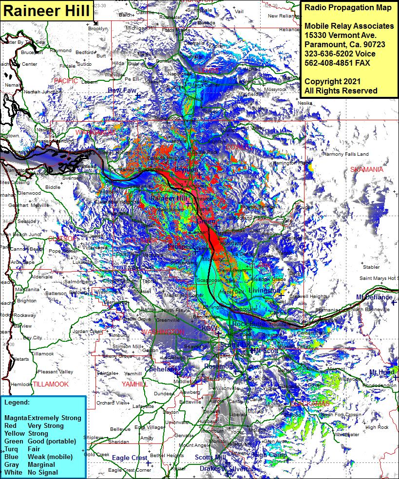
Site Coverage: Coverage of Beaver Springs, Goble, Kalama, Apiary, Mist, Natal, Jewel, Keasey, Vermonia, Corey Hill, Clear Creek, Coyote Corner, Timber, Scofield, Staleys Jct, Buxton, Glenwood, Manning, Meacham Corner, Snooseville Corner, Banks, Mountaindale, Roy, Vadis, North Plains, Starkey Corner, Schefflin, Thatcher, Verboort, Mahan, Merle, Bethany, Valle Vista, Folkenberg, Holbrook, Vancouver Jct, River Jct, North Portland, Whitwood Court, Fir, Parkrose, Fisher, McLoughlin, Vancouver, Hazel Dell, Orchards, Proebstel, Ireland, Fern Prarie, Creswell Heights, Camas, Interlachen, Troutdale, Corbett Station, Wood Village, Graham, Merle, Hillsboro, Tobias, Blooming, Jacktown, Hazeldale, Metzger, Beaverton, Tigard, Ladd, Lake Oswego, Sunnyside, Wilson Corner, Anderson, Haley, Orient, Kelso, Sandy, Alma, Barton, Carver, Eagle Creek, Sherwood, Middleton, Six Corners, Tualatin, Scholls, Kinton, Greenburg, Laurel, Laurelwood, Felida. Salmon Creek. Sara. Brush Prairie, Hockinson, Scotton Corner. Venersborg. Dole, Crawford. Heisson, Lucia, Yacolt, Fargher Lake, Amboy, Chelatchie, Pine Grove, La Center, Charter Oak, King Corner, Good Hope, Woodland, Pine Grove, Hayes, Etna, Ariel, Columbia City, Deer Island, Canaan, Trenholm, Saint Helens, McNutty, Warren, Spitzenberg, Chapman, Vermonia, Dr Rankins Place, Oak Point, Bunker Hill, Eufaula Heights, Columbia Heights, Longview, Longview Jct, Pleasant Hill, Castle Rock, Siverlake, Sightly, Toutle, Saint Helens, Olequa, Rydenwood, Herington Place, Pigeon Springs, Woodland Park
