Rosemont
| Site Name: | Rosemont | 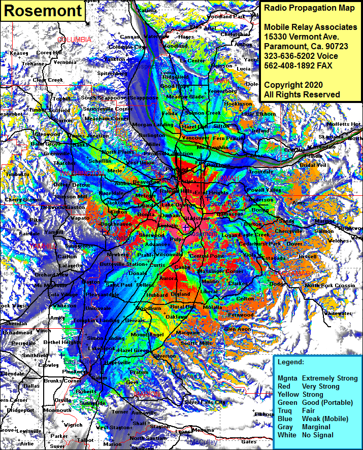 Rosemont Coverage |
| Latitude: | 045 22 04.7N | 45.3679722 |
| Longitude: | 122 38 33.0W | -122.6425000 |
| Feet | Meters | |
| Ground Elevation: | 690.0 | 210.3 |
| HAAT: | 524.0 | 159.7 |
| City: | Concord | |
| County: | Multnomah | |
| State: | Oregon |
This is not an MRA Owned Site. For space rental contact the site owner.
Do you own or manage this site? Click Here
Would you like to add a site to the Google Earth Map?? Click Here
Site Coverage: Coverage of Portland, Saint Johns, Miller, Rafton, Holbrook, Seappoose, Salmon Creek, Vancouver, Interlachen, Fern Prarie, Ireland, Cresswell Heights, Little Elkhorn, Mount Pleasant, Gresham, Anderson, Kelso, Sandy, Finwood, Aims, Dover, George, Eagle Creek, Estacada, Dodge, Elwood, Timber Grove, Colton, Fernwood, Glen Avon, Wilhoit, Scotts Mills, Marquam, Mount Angel, Downs, Silverton, Middle Grove, Chapman Corner, Zena, Bethel, Amity, Eola Village, Lafayette, Carlton, Yamhill, Wapato, Laurelwood, Blooming, Stimson Mill, Watts, Thatcher, Hayward, Buston, Scoffield, North Plains, Merle, Beaverton, Durham, Norwood, Fargo, Woodburn, Gervais and more…….