Scott PDX
| Site Name: | Scott PDX | 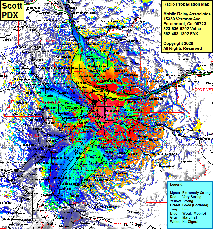 Scott PDX Coverage |
| Latitude: | 045 27 17.0N | 45.4547222 |
| Longitude: | 122 33 02.6W | -122.5507222 |
| Feet | Meters | |
| Ground Elevation: | 1049.0 | 319.7 |
| HAAT: | 854.8 | 260.5 |
| City: | Harmony | |
| County: | Clackamas | |
| State: | Oregon |
This is not an MRA Owned Site. For space rental contact the site owner.
Do you own or manage this site? Click Here
Would you like to add a site to the Google Earth Map?? Click Here
Site Coverage: Coverage of Portland, Vancouver, Blurock Landing, Hazel, Knapp Landing, Dollar Corner, Ridgefeld, Woodland, Deer Island, La Center, Hasson, Lucia, Venersborg, Dole, Hockinson, Little Eklhorn, Ireland, Fern Prarie, Orchards, Prindle, Cruzatt, Corbett Stn, Gresham, Haley, Orient, Alms, Kelso, WIlson Corner, Sandy, Cherryville, Salmon, Marmot, Brightwood, George, Dover, Paradise Park, Viola, Estacada, Dodge, Elwood, North Fork Crossing, Colton, Fernwood, Scotts Mills, Mount Angel, Silverton, Hayesville, Labish Village, Simon Landing, Unionvale, Pleasantdale, Dayton, Eola Village, Amity, Saint Joseph, Carlton, Yamhill, Gaston, Blooming, Hillsboro, Merle, Starkey Corner, Banks, North Plains, Davies Jct and more…..