Bony Peak
| Site Name: | Bony Peak | 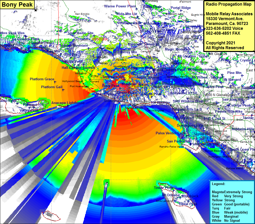 Bony Peak Coverage |
| Latitude: | 034 07 58.4N | 34.1328889 |
| Longitude: | 118 55 29.0W | -118.9247222 |
| Feet | Meters | |
| Ground Elevation: | 2864.0 | 872.9 |
| HAAT: | 2151.2 | 655.69 |
| City: | Newberry Park | |
| County: | Ventura | |
| State: | California |
This is not an MRA Owned Site. For space rental contact the site owner.
Do you own or manage this site? Click Here
Would you like to add a site to the Google Earth Map?? Click Here
Site Coverage: Coverage of Port Hueneme, Silver Strand, Hollywood Beach, Oxnard, Leesdale, Camarillo, Greenwich Village, Thousand Oaks, Triunfo Corner, Cornell, Maliby Junction, Calabasas Post Office, Hidden Hills, Calabasas Highland, Sylvia, Woodland Hills, Los Angeles, Canoga Park, WInnetka, Reseda, Northridge, Chatsworth, Granada Hills, Raymer, Panorama City, Gemco, Sun Valley, Pacoima, San Fernando, Sylmar, Olive View, Stonehurst, Hewitt, Vega, North Hollywood, Burbank, Park La Brea, Vernon, Hobart, Florence, WIndsor Hills, Inglewood, Lennox, LA Airport, Gardena, Lawndale, Manhattan Beach, El Nido, Lomita, Avalon Village, Watson Jct, Palos Verdes Estates, Manhattan Beach, Santa Susana, Simi, Simi Valley, Strathearn, Moorpark, Fairview, Mountclef Village, Greenwich Village, Newberry Park, Lagol, Somis, West Saticoy, Limoneira, Bardsdale, Sespe Village, Keith, Sespe, Fillmore, Cavin, Buckhorn, Piru, West Saticoy, Kimball, El Rio, Pierpont Bay, Ventura, Dulah, Sea Cliff, Punta, Old Town, Sandyland Cove, Serena, Summerland, Montecito, Santa Barbara, La Patera, Coromar, Ellwood, Naples, Montecito
Amateur (ham) frequencies: