Cub Peak
| Site Name: | Cub Peak | 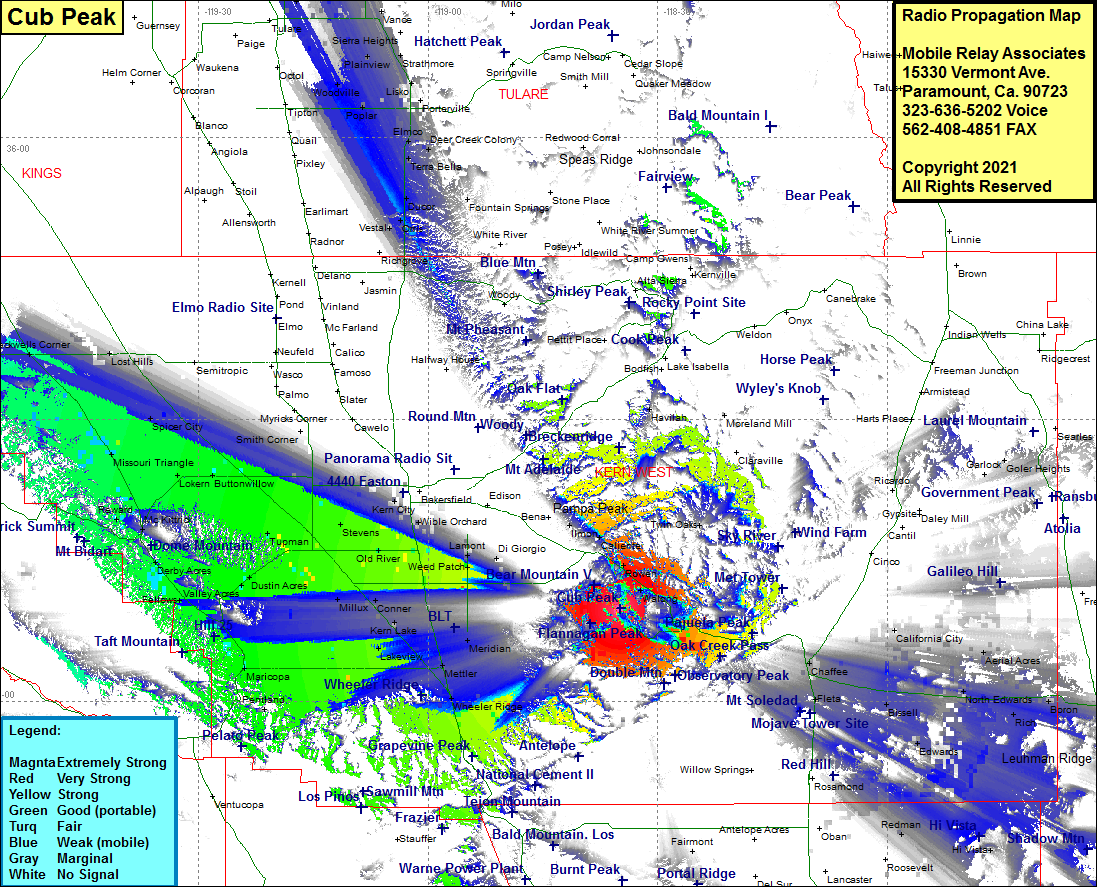 Cub Peak Coverage |
| Latitude: | 035 09 50.8N | 35.1641111 |
| Longitude: | 118 34 50.0W | -118.5805556 |
| Feet | Meters | |
| Ground Elevation: | 5917.0 | 1803.5 |
| HAAT: | 1851.7 | 564.4 |
| City: | Bear Valley Springs | |
| County: | Kern | |
| State: | California |
This is not an MRA Owned Site. For space rental contact the site owner.
Do you own or manage this site? Click Here
Would you like to add a site to the Google Earth Map?? Click Here
Site Coverage: Coverage of Tehachapi, Summit, Manolith, Old Town, Cable, Walong, Woodford, Keene, Rowen, Bealville, Caliente, Ilmon, Fig Orchard, Twin Oaks, Maave, Chaffee, Aerial Acres, North Edwards, Desert Lake, Boron, Kramer Junction, Houze Place, Hi Vista, Redman, Ansel, Fleta, Sanborn, Bissell, Edwards, Greenfield, Lamont, Weed Patch, Mitchells Corner, Alameda, Old River, Gosford, Kern City, Una, Rio Bravo, Buttonwillow, Spicer City, Missouri Trianble, Lokern, Tupman, Jillux, Conner, Kern Lake, Lakeview, Mettler, Meridian, Pentland, Maricopa, Spellacy, Taft, Ford City, Midoil, Fellows, Valley Acres, Dustin Acres, Derby Acres, Reward, Lost Hills, Blackwells Corner, Vestal, Orris, Ducor, Terra Bella, Ultra, Deer Creek Colony, Elmco, Lois, Magnolia, Plano, Ponce, Nanceville, Cotton Center, Poplar, Lairds Corner, Lower Corner, Lisko, Zante, Strathmore, Plainview, Mirador, Stout, Burr, Cairns Corner, List, Mitchell Corner, Rector, Farmersville, Rector, Ambles, Spinks Corner, Chinowths Corner
Amateur (ham) frequencies: