Elmo Radio Site
| Site Name: | Elmo Radio Site | 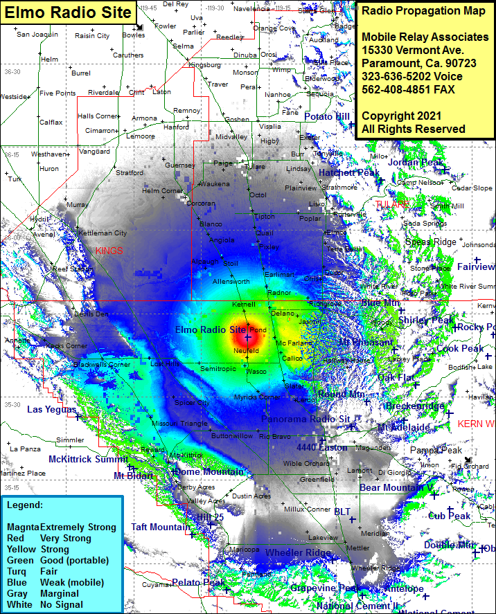 Elmo Radio Site Coverage |
| Latitude: | 035 40 47.4N | 35.6798333 |
| Longitude: | 119 19 49.1W | -119.3303056 |
| Feet | Meters | |
| Ground Elevation: | 296.0 | 90.2 |
| HAAT: | 135.0 | 41.2 |
| City: | Elmo | |
| County: | Kern | |
| State: | California |
This is not an MRA Owned Site. For space rental contact the site owner.
Do you own or manage this site? Click Here
Would you like to add a site to the Google Earth Map?? Click Here
Site Coverage: Coverage of Elmo, Neufeld, Wasco, Palmo, Myricks Corner, Thomas Lane, Crome, Hights Corner, Rio Bravo, Millux, Pentland, Maricopa, Spellacy, Taft, Ford City, Fellows, Valley Acres, Dustin Acres, Derby Acres, Tupman, Buttonwillow, Lokern, Derby Acres, Reward, Missouri Triangle, Spicer City, Semitropic, Lost Hills, Blackwells Corner, Kecks Corner, Devils Den, Reef Station, Avenal, Kettleman City, Hydril, Stratford, Guernsey, Helm Corner, Corcoran, Waukena, Paige, Blanco, Angiola, Stoil, Alpaugh, Allensworth, Kernell, Pond, Paige, Octol, Taqua, Midvalley, Swall, Loma, Higby, Tipton, Quail, Pixley, Earlimart, Radnor, Jovista, Delano, Vinland, McFarland, Trocha, Quality, Richgrove, Vestal, Orris, Ducor, Terra Bella, Elmco, Lois Ponoa, Cotton Center, Poplar, Lower Corner, Nanceville, Plainview, Zante, Strathmore, El Mirador, Lindsay, Vance, Tonyville, Burr, Farmersville, Antes, Porterville, Worth, Plano, Magnola, Deer Creek Colony, Halfway House, Minter Village, Cherokee Strip, Kern City, Gosford, Stevens, Old River, Greenfield, Alameda, Harpertown, Wible Orchard, Kayandee, Bakersfield, Angunden, Lonsmith, Filler Acres, Lamont, Weed Patch, Meridian, Metler, Wheeler Ridge, Kern Lake, Lakeview, Conner, Old River
Amateur (ham) frequencies: