Flannagan Peak
| Site Name: | Flannagan Peak | 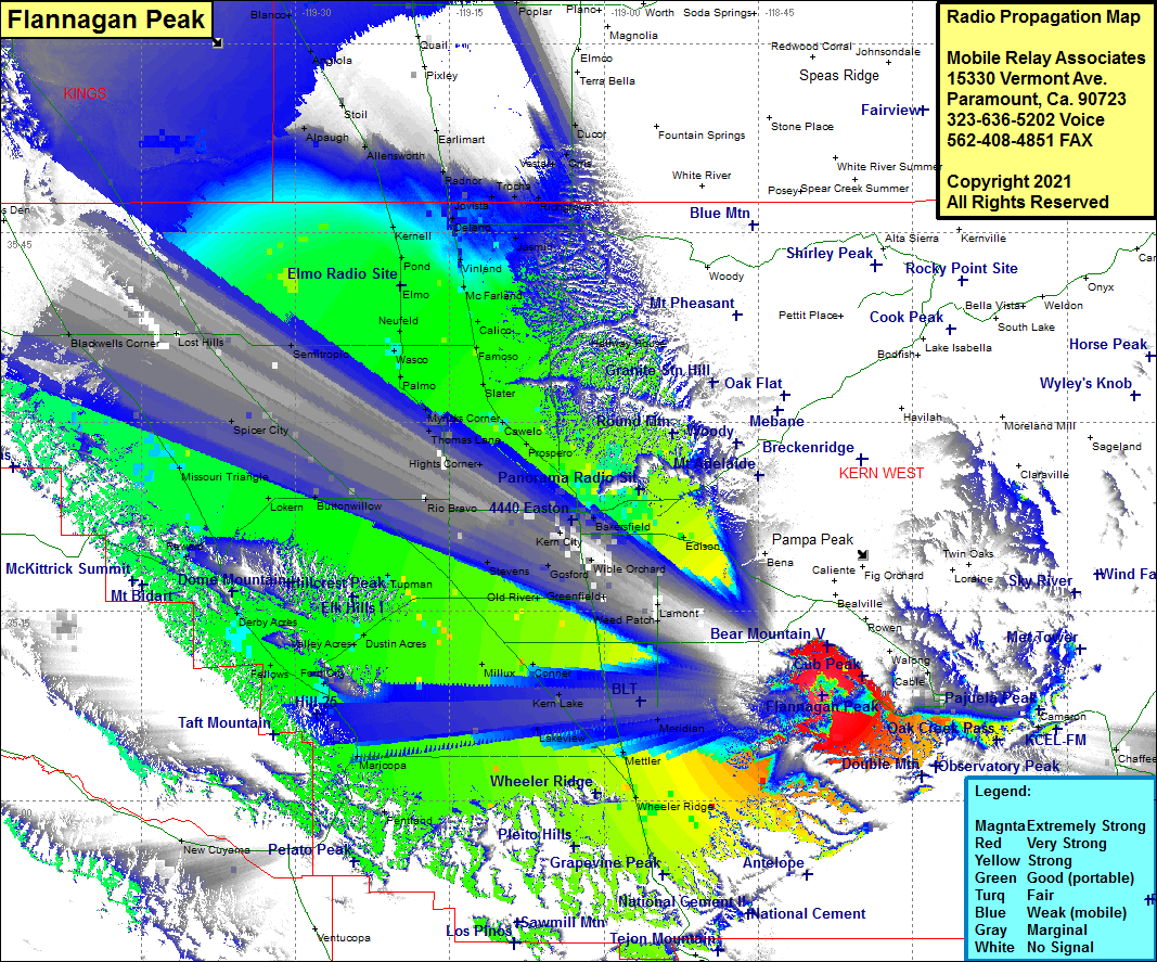 Flannagan Peak Coverage |
| Latitude: | 035 08 20.7N | 35.1390833 |
| Longitude: | 118 38 44.1W | -118.6455833 |
| Feet | Meters | |
| Ground Elevation: | 5295.0 | 1613.9 |
| HAAT: | 1885.4 | 574.7 |
| City: | Tehachapi | |
| County: | Kern | |
| State: | California |
This is not an MRA Owned Site. For space rental contact the site owner.
Do you own or manage this site? Click Here
Would you like to add a site to the Google Earth Map?? Click Here
Site Coverage: Coverage of Tehachapi, Cable, Grapevine, Wheeler Ridge, Mettler, Meridian, Kern Lake, Edmundson Acres, Mitchells Corner, Weed Patch, Ribie, Lamont, DiGiorgio, Alameda, Greenfield, Hapertown, Fuller Acres, Panama, Old River, Gulf, Millux, Lakeview, Maricopa, Pentland, Fellows, Valley Acres, Dustin Acres, Tupman, Lokern, Missouri Triangle, Buttonwillow, Spicer City, Semitropic, Lost Hills, Blackwells Corner, Kecks Corner, Kettleman City, Murray, Hydril, Avenal, Huron, Westhaven, Vanguard, Stratford, Helm Corner, Guernsey, Hanford, Remnay, Armona, Lemoore, Cimarron, Halls Corner, Grangeville, Pitco, Hardwick, Laton, Goshen, Midvalley, Tagus, Swall, Loma, Higby, Tulare, Paige, Waukena, Corcoran, Blanco, Angiola, Stoil, Allenworth, Alpaugh, Kernell, Pond, Elmo, Newfeld, Wasco, Palmo, Slater, Famoso, Calico, McFarland, Vinland, Delano, Quality, Jovista, Trocha, Richgrove, Vestal, Cawelo, Prospero, Kern City, Gosford, Stevens, Old River, Algoso, Halfway House
Amateur (ham) frequencies: