Mt Bidart
| Site Name: | Mt Bidart | 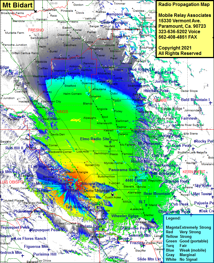 Mt Bidart Coverage |
| Latitude: | 035 17 03.8N | 35.2843889 |
| Longitude: | 119 44 53.9W | -119.7483056 |
| Feet | Meters | |
| Ground Elevation: | 4188.0 | 1276.5 |
| HAAT: | 2090.7 | 637.2 |
| City: | McKittrick | |
| County: | Kern | |
| State: | California |
This is not an MRA Owned Site. For space rental contact the site owner.
Do you own or manage this site? Click Here
Would you like to add a site to the Google Earth Map?? Click Here
Site Coverage: Coverage of Martinez Place, Todd Place, La Panza, Simmler, Reward, Missouri Triangle, Blackwells Corner, Kerns Corner, Reef Station, Avenal, Hydril, Kettleman City, Murray, Huron, Westhaven, Vanguard, Stratford, Cimarron, Calflax, Cimarron, Halls Corner, Riverdale, Burrel, Five Points, Westside, Rasin City, Elm View, Cauthers, Conejo, Selma, Fowler, Calwa, Del Rey, Parlier, Lacjac, Reedley, Kingsburg, Traver, Goshen, Lenmoore, Armona, Pitco, Clint, Laton, Remnoy, Hanford, Guernsey, Helm Corner, Waukena, Paige, Corcoran, Blanco, Angiola, Alpaugh, Stoil, Allensworth, Kernell, Pond, Newfeld, Semitropic, Wasco, Lost Hills, Myricks Corner, North Shafter, Mexican Colony, Spicer City, Buttonwillow, Rio Bravo, Wible Orchard, Bakersfield, Lamont, DiGiorgio, Meridian, Mettler, Lakefiew, Kern Lake, Millux, Conner, Old River, Dustin Acres, Valey Acres, Derby Acres, Cuyama, New Cuyama, Maricopa, Pentland, Ventucopa
Amateur (ham) frequencies: