Snowbird Mtn
| Site Name: | Snowbird Mtn | 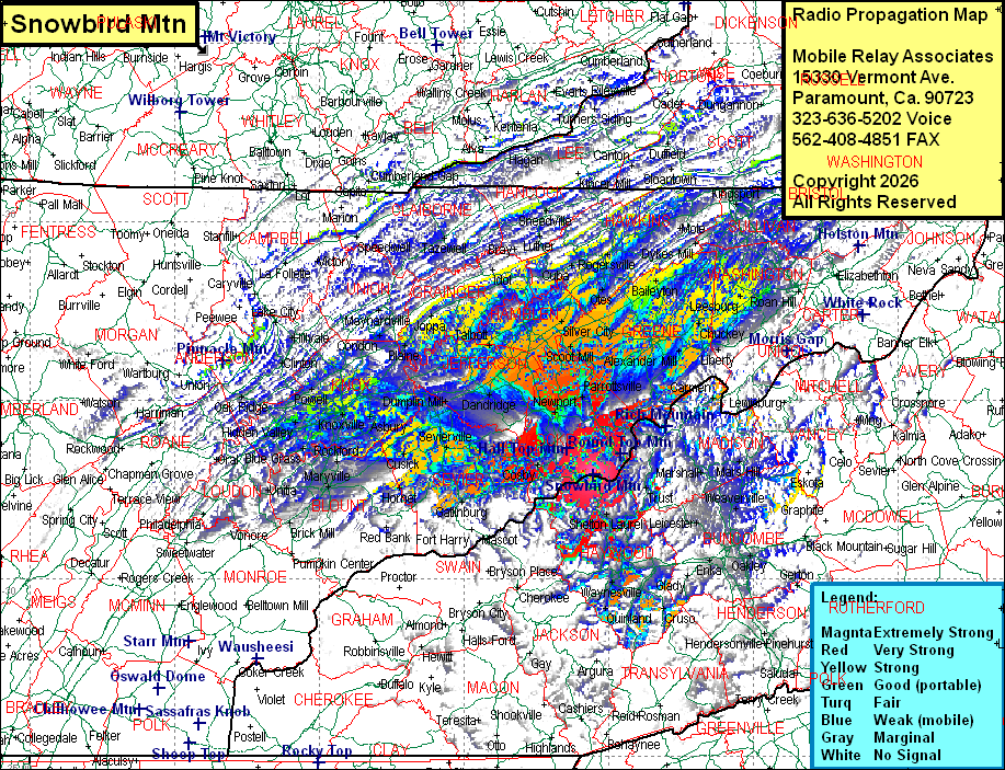 Snowbird Mtn Coverage |
| Latitude: | 035 47 24.3N | 35.7900833 |
| Longitude: | 083 03 08.3W | -83.0523056 |
| Feet | Meters | |
| Ground Elevation: | 4262.0 | 1299.1 |
| HAAT: | 1770.2 | 539.6 |
| City: | Hartford | |
| County: | Cocke | |
| State: | Tennessee |
This is not an MRA Owned Site. For space rental contact the site owner.
Do you own or manage this site? Click Here
Would you like to add a site to the Google Earth Map?? Click Here
Site Coverage: Coverage of Cocke, Jefferson, Hamblen, Greene, Washington, Grainger Counties, much of Hawkins, Servier, Blount, Knox, Hancock, Hawkins Counties, some of Haywood (NC) County and sporatic coverage of Johnson, Carter, Unicoi, Sullivan, Monroe, Roane, Anderson, Campbell, Scott, Morgan, Cumberland, Rhea, McMinn, Transylvania (NC), Jackson (NC), Macon (NC), Graham (NC), Swain (NC), Henderson (NC), Polk (NC), McDowell (NC), Avery (NC), Watauga (NC), Mitchell (NC), Madison (NC), Washington (VA), Bristol (VA), Scott (VA), Russell (VA), Dickenson (VA), Wise (VA), Norton (VA), Lee (VA), McCreary (KY), Whitley (KY), Knox (KY), Bell (KY), Harlan (KY), Letcher (KY), Leslie (KY), Clay (KY), Knox (KY), Whitley (KY), Laurel (KY), Perry (KY) Counties