Bells Mtn
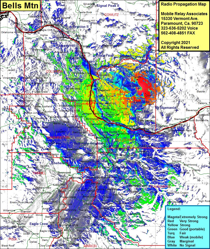
| Site Name: | Bells Mtn |  Bells Mtn Coverage |
| Latitude: | 045 48 49.4N | 45.8137222 |
| Longitude: | 122 23 30.8W | -122.3918889 |
| Feet | Meters | |
| Ground Elevation: | 2213.0 | 674.5 |
| HAAT: | 1208.6 | 368.4 |
| City: | Yacolt | |
| County: | Clark | |
| State: | Washington |
This is not an MRA Owned Site. For space rental contact the site owner.
Do you own or manage this site? Click Here
Would you like to add a site to the Google Earth Map?? Click Here
Site Coverage: Coverage of Fargher Lake, Amboy, Chelatchie, Yale, Cougar, Woodland Park, Ariel, Etna, Hayes, Pine Grove, La Center, Ridgefield, Sara Helida, Vancouver Jct, Blurock Landing, Vancouver, Hazel Dell, Rye, Salmon Creek, Charger Oak, Cherry Grove, Battle Ground, Good Hope, Brush, Prairie, Union, Sifton, Orchards, Fern Prairie, Creswell Heights, Hockinson, Scotton Corner, Venersborg, Dole, Heisson, Lucia, Yacolt, McLoughlin, Fisher, Camas, Washougal, Mt Pleasant, Bartlett Landing, Parker Landing Lighthouse, Fir, Parkrose, Interlachen, Wood Village, Troutdale, Corbett Station, Gresham, Anderson, Orient, Cottrell, Aims, Hillsview, Wilson Corner, Kelso, Sandy, Firwood, Dover, Paradise Park, Viola, Logan, Eagle Creek, Arton, Carver, Outlook, Oregon City, Echo Dell, Sunset, West Linn, Clackamas, Bellrose, Jenne, Powelhurst, Arleta, Haig, Portland, Willbridge, Gasco, Linnton, East St Johns, North Portland, Miller, Burlington, Holbrook, Johnson Crossing, Scappoose, Valle Vista, Warren, McNulty, Saint Helens, Columbia City, Deer Island, Canaan, Trenholm, Chapman, Spitzenberg, Warren, Mountaindale, Vadis, North Plains, Starkey Corner, Bendemeer, Merle, Quatama, Newton, Blooming, Jacktown, Kinton, Greenburg, Bull Mountain, Hazeldale, Aloha, Quatama, Merle, Forest Gove Jct, Schefflin, Roy, Banks, Thatcher, Watts, Davies Jct, Scholls, Bull Mountain, Tualawn, Hermah, Chipole, Sherwood, Mulloy, Votaw, Middleton, Chehalem
